
View from the Legacy Trail between Canmore and Banff.
My goal could not have been achieved without my good friends in Calgary, their patience with my last-minute, scatterpuss lifestyle and the house in which they live. I am very lucky to have been able to go back to Calgary after each of these past three tree planting seasons and use Calgary as a western home base -and, particularly this year, a gateway to the mountains. Not to mention the presence of my Calgarian friends was paramount in the goal achievement itself!
Although it lacks mountains, it's worth mentioning that my freedom adventures began with me rolling off a Greyhound, grabbing my bike that had been stored at the house in Calgary, buying a ticket to Calgary Folk Fest off Kijiji and entering a crowded world full of friends, strangers and new acquaintenances amongst amazing musicians and so much FOOOOD (my planting appetite would not subside until a few weeks ago). Needlesstosay I was overstimulated and could not stay out beyond midnight that night. After a morning in the zen den the next day I was ready to continue the party. I had been wanting to attend Calgary Folk Fest for years and this planting season ended early enough to allow me to part take in a day and a half of it. I finally got to see Calgary in its prime. For those of you who know me, you know that I dislike Calgary for many reasons (and I will not elaborate here), but locals had always told me that I needed to attend Folk Fest in order to experience the "real" Calgary. And so, I did. Calgary was the happiest place on Earth that weekend. It's hard to be miserable when all of your friends are attending the same event with good music and beer in equal quantities. Quality food abound and it's all outside! The festival takes over Prince's Island Park situated in the heart of the city and surrounded by Bow River. What a setting, what a scene. I'm glad I went and I hope to go again.
After spending a couple of days saying goodbye to lingering planting friends visiting the city I began my journey west. I biked from Calgary to Kananaskis, specifically Barrier Lake, and camped out at Jewel Bay. The cycle was kind of brutal given it was over 30 degrees Celcius, not a cloud in the sky and no where to fill up my water. So I ran out. If anyone visited the Kananaskis Casino August 1st-ish, you may have seen a girl passed out on the side walk in front of the entrance periodically gaining consciousness only to chug water. I sometimes forget that just because I'm in Canada and not Africa I cannot assume water is readily available everywhere for my taking. I could have just stopped at the oddly placed Subway in a sad town called Morley, but refused for some reason. It might have been one of those times that I was gaining speed going downhill before reaching an uphill, therefore couldn't bring myself to lose precious momentum. I've got to give myself a slap in those moments and bite the bullet. Water is life!

Very flat before you hit the Rockies.

First sight of mountains!

Jewel Bay was a gorgeous place to camp. You would never suspect that you're on a man-made lake by the Highway 40. To get there you either have to paddle to the opposite end of the lake to where the heavily populated beaches are or bike the double track around the far side of the lake. I, of course, biked. A lovely bike ride with little to get the heart going until I encountered a black bear! My first ever bear encounter on the bike. It happened to be off the trail, but at a section of the trail with little vegetation between the trail and the lake on a steep slope. Of course the bear was just as startled as I was, so she started running parallel to me. She stopped and stood upright looking at me right when I had the steepest ascent to climb on the whole trail, steep enough that I couldn't pedal, I had to push the bike up. Great timing. So I pushed the bike up as fast as I could periodically looking behind me to see if the bear was following me. I couldn't see her. I looked back again once I reached the top and she was nowhere in sight. I continued pedalling for a mere 100 meters until I reached the campsite, informing everyone there (many children!) that there was a bear nearby. We never did see the bear again. That was an exciting and overall positive experience! I knew that with the number of kms I was to pedal on the bike in western Canada, I was bound to encounter a bear. I'm glad I finaly did as the fear of the unknown has now subsided and I can feel more prepared for the next encounter. Jewel Bay campsite is small, with only 8 or so spots, so it feels secluded enough given its proximity to civilization. I set-up my Hennesy Expedition hammock next to the communal eating area because those trees had the best view. I woke up with a stunning view of the lake unimpeded by anything. Polar bear dips in the morning were the best way to wake up. The first night at Jewel Bay was spent with some friends that happened to be there. We surprised each other! What a lovely surprise it was. The next day was spent on the beach side of Barrier with a different group of friends -a planned visit. And the second night was spent with various parents and their children who were all part of the YMCA Camp Hector across the highway. A Calgary City Urban Planner, a politcal party member and a couple of ex-planters pegged me as a planter from the get-go and we chatted about their respective subjects of expertise as well as Star Wars and other movies of that era that I am too young to know about....or so they said.

Barrier Lake.

My hammock set-up in Jewel Bay campground looking out on Barrier Lake.

View from the inside of my hammock.

The plan for the next day was to meet up with Calgary friends at a crag near to the Quaite campsite, just a few km's on some single track I was told was doable with a loaded bicycle. Surely nothing can stop the Troll. I've done some single track with the Surly Troll before, but never while it was loaded down with panniers. Now that I've tried it, I will never do it again. I pushed that bike up most of the way. For some reason all the technical bits with the roots, rocks and narrow/steep-as trail were on the uphill, while the downhill was a breeze -nothing but pine needles on smooth double track. To add to the intensity and difficulty of the uphill, that particular bit of trail was exceedingly popular and folks from all over the planet happened to be there. You can just imagine how many "Boy, you have a lot of stuff!" and, "My, that looks heavy." and, "Wow, you're strong!" comments I received as I inched the 40kg Troll up 20% grade roots and rocks. Sometimes I felt empowered by these statements, but mostly I felt annoyed. Note to bistanders on trails: when you see someone pushing a loaded bicycle up a trecherous hill, commenting on how heavy the bike looks doesn't help :). It's tough to put yourself in the hikers' shoes and realize that they mean no harm, but I managed to keep a smile on my face and nod in agreeance -what else could I possibly do between huffs and puffs? There was no chance in me actually verbalizing anything for fear of choking on my own sweat pouring down my face or, worst, passing out from missing a breath with each word I might speak. Although most cyclists who were mountain biking without a load were empathetic enough to let me pass them, there was this one old crotchity dude that felt the need to look at me from the top of the steepest hill on the trail while I struggled to keep the Troll moving forward and my feet from slipping backward, dismount and lift his steed and push past me on a trail no wider than a pannier on either side of a bike. He had enough nerve to tell me that I am going the wrong way and that I have the wrong bike and that it is difficult ahead. I would most certainly have taken another "Hey, your bike looks heavy." comment over this pompous arse's ego. Where does he get off?, I thought. I responded with, "In too much of a hurry to wait?" and he didn't respond. Once I reached the top of this hill, only a few meters from this encounter, I looked back down and noticed the old fart was in a hurry to rest! He had set his bike down by some water and was taking pictures and getting ready to sit himself down. The nerve. This encounter clearly stuck with me and probably will for a long time. This kind of behaviour just doesn't make sense to me. What did he gain from being such an ass? I guess I'll never know.

One of a couple of bridge crossings along the single track from Jewel Bay to Quaite campground.
Quaite campground was much bigger than Jewel Bay with dozens of campsites, but it was a mere 5 minute bike ride from the crag. So I rested and waited at the campsite for my friends to show up (I had cell reception as the campsite is only 2km from the Trans Canada highway) and biked down to them. We climbed several routes while enjoying each other's company. I had been looking forward to using the strength I gained tree planting, as I do each year and was very pleased that this was coming into fruition. I was grateful for my friends to have hiked in ropes and various other heavy climbing gear to make for a successful evening. This gathering led to another successful set of days and evenings as I found out a canoe trip was in the works, so I invited myself, naturally. It was all set, I was to bike out to Canmore the next morning, store my bike at a friend's sister's place, and get picked up to drive to kilometer 35? 36? down a logging road and paddle down the Kootenay river for a couple of days to take out at Canal Flats. A week into freedom and I've already covered so much of my goal: cycle touring, climbing, paddling and spending time with friends in the mountains. I was well on my way to a successful August indeed!

Although we didn't leave Canmore nearly as early as planned, we put in the canoes at a decent enough time to get an hour and a half worth of paddling in or so -enough to find "the spot". A place described to our paddling leader as a paradise, a piece of beach around the bend from a gorgeous, tall rock wall that looked like it didn't belong. We knew as soon as we saw it that we had hit the jack-pot. A paradise it was. Someone had taken the time to jazz it up a little with a tikki bar and "kitchen" space. Seating around a fire pit and ample room for 10 tents and even more hammocks if a large group were to occupy this tropical-esque haven in the Canadian Kootenays. We were lucky, very lucky that we arrived when we did. Over the day and a half that we spent on that beach, two other parties stopped to gawk, presumably with a slice of desire and jealousy, and contemplate sharing the space with us. We, of course, welcomed them and offered to share the sand and trees, but we didn't push anything. Both parties continued down the river with new knowledge that such a paradise exists. We would learn later when we continued down the river that there were many other beaches to spend the night along the way, but nothing compared to our private pad. We enjoyed fire, good food, drink and weather during our stay. A storm on the second night forced two of us to pack away our hammocks and share a tent with another friend, leaving our third friend alone with his lovely, but wet stinky dog in a much larger tent. The storm, however, offered a light show like one I had never seen before. We had a fire going, so although we were getting a little wet, we remained relatively warm, which allowed us to watch as several storms came and went overhead and lightening periodically lit-up the rock wall face across the beach -the one that indicated our location upon first arrival. The brief seconds each lightening rod permitted sight revealed several faces on the rock wall. It was a magical, natural visual effect only comparable to the Arora Borealis in its splendor, but completely different at the same time. This went on for about half an hour or 45 minutes. We were able to escape the really heavy rain as it started in a timely manner -as soon as we entered our tents. The pitter-patter a quintessential lullaby of the great outdoors.

Our tikki bar complete with tarp to keep us dry. Photo credit: Kevin Bruch

Plenty of room for many tents. Photo credit: Kevin Bruch

What is a beach paradise without hammocks? Photo credit: Kevin Bruch

I had done a bunch of paddling on lakes back in Ontario as a child and some on calm rivers with hardly any current in Central and South America, but never had I ever experienced rapids in a canoe. The southern part of the Kootenay, where we were paddling, does not offer the experienced paddler much in terms of a challenge, but for someone like me who had never had to think about how to paddle through currents and small rapids it was a blast! I was lucky enough to sit in the bow while a kayak guide and former competitor in white-water kayaking managed the stern. He is used to teaching small children, so I'm sure he found I was no different than his students when teaching me how to turn into eddies and paddle through small rapids. I had so much fun. I hope to do more bigger river paddles in the future.

View across the river from the beach as stormy clouds rolled in. Photo credit: Kevin Bruch
Next on the to do list: hiking. The Skoki region was recommended to myself and a companion. We rented a car and the mountains all of a sudden became far more accessible. We camped at Two Jack, a campsite along a road that takes you high up in the forests on the side of Banff's mountains. The next day we inquired about camping in the Skoki region at the Banff visitor's centre. They usually look puzzled when you ask about camping the night of, but we were in luck, the campsite furthest away in the Skoki was available that night and we could hike out to the closer campsite the next day. Perfect. So we hiked some of the fire road up on the way to the trail head and were offered a ride by a Lake Louise shuttle employee the rest of the way to the trail head. Thank goodess because that road seemed to last forever and get steeper and steeper with no views. Once we reached the trail head we hiked up and down a couple of passes amongst glaciers, glacial lakes, waterfalls and endless mountain peaks for about 15 kms to Red Deer campsite. Another small campground with about 5 sites or so. A peaceful spot with two other tents. We had left late in the day, so we had just enough time to cook a rather labour-intensive dinner camping-wise and go to bed. We retraced our steps stopping to enjoy the breath-taking views once more, including the two-tiered lake system, each lake exhibiting a variation of the colour torquoise with waterfalls feeding from one lake to another and originating from the glacier above. We reached Hidden Lake, our campground for the night and found a little nook hidden amongst trees we thought was rather clever and secluded. Much to our surprise, however, we weren't alone. A porcupine woke us in the night scratching at our tent trying to join us! I had never experienced a porcupine so intrusively and so determined to get in our tent. We were able to scare it back up the tree, however, she or he must have been hungry and night time is the time to forage for this nocturnal creature. So we had to be patient and listen for her to return to ground level and give her the chance to run away from our tent without scaring her back up the tree. I think we gained mutual respect as we were not bothered again. Before retiring for the night we had to see what this hidden lake was all about. So we ventured up a trail that took us higher and higher, not something you expect when moving towards a body of water. Eventually, after crossing a river and rising above the alpine we reached the hidden lake. We could see in that moment why it was referred to as "hidden". Mountains toward around it and it was high enough up that those trapesing the area would have to go well out of their way to find it. It was ours for the evening to enjoy its majesty. My companion had never visted Lake Louise, so I was compelled to show him its majesty. I won't say this was a mistake, but I was certainly taken aback. I had only visited Lake Louise in the wintertime. This was a summer Sunday in August -Lake Louise in turn became what seemed like an amusement park. The crowds were unbearable, full of only the wealthiest of travelers. Selfie sticks abound people were out of control. It's as if tourists turn off their brains when they're visiting a place other than their place of residence. The people were quite zoo-like, an embarrassment to humanity and our supposed stewardship to the beauty we're meant to preserve on this earth. Perhaps not all, but certainly most of Lake Louise's beauty was taken away in such a setting.
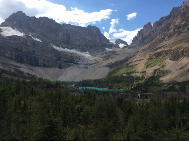
Two-tiered torquoise glacial lakes.

View from Deception Pass looking south at Ptarmigan Lake.

View from Deception Pass looking north.

Deception Pass.

Ptarmigan Lake.

One of many beautiful peaks along the trail.

Somewhere under those mountains is Hidden Lake.

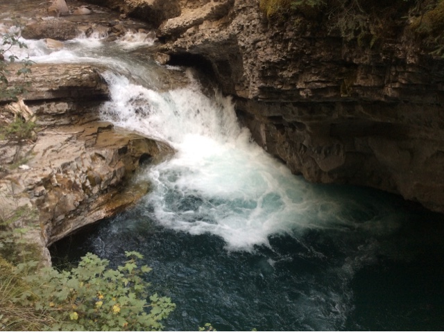
I somehow found a ride back to Canmore from Calgary after hiking adventures and was able to retrieve my bike, slap the panniers back on and continue adventuring solo. I road the Legacy Way trail from Canmore to Banff and continued to Lake Louise on the Bow Valley Parkway sleeping at the Johnston Canyon campground along the way. The Legacy Way trail was great because it meant I didn't have to share the highway with motorised vehicles. Although I had to share the road on the Bow Valley Parkway, the speed limit is only 60km/hr and this windy road is much less busy than the TransCan. A very peaceful road indeed allowing for many rest stops and mountain viewing, particularly the infamous Castle Mountain. My intension was to hike to Johnston Canyon early-ish in the morning in order to beat any crowds, but I noticed a broken chain link while lubing-up, so that took about 45 mins to fix and before you know it, after having to unpack and repack the bike it's almost 11am once I reached the trailhead. The crowds were even more intense than I had expected. Similar to those of Lake Louise, people without much thought, pushing each other out of the way attempting to get a picture without other people in the background. A line up formed to take a picture of the lower falls from under the limstone bridge. I couldn't bring myself to wait in line, again as if I was in an amusement park. There are plenty of other equally if not more spectacular waterfalls and canyons in this world, but because this is "Johnston Canyon" people need to fullfill their checklists and make sure their friends and family know that they were there. They were at that place that is talked about by other people that maybe some people abroad would recognize. Good for them. I wonder how many of them stopped for a moment, put down their memory-making technology to actually take-in and appreciate what they were witnessing. I wonder how many people actually read the signs that talk of the history we walked upon to get to the falls, of the orgins and destinations of those waters, why the water is the colour it is, why the canyon formed or NOT TO FEED THE SQUIRRELS? I'm sure the latter is read, it's impossible to miss the frequently encountered "Do Not Feed" signs, but blatently ignored. Everyone finds some justification or another to habituate the wildlife or walk off trail to destroy plant life that can take decades, or sometimes centuries, to grow. Their selfie with the fat ground squirrel aiming for their purse is far more important than the long term effects of that photo or their footsteps.

View from the Legacy Way trail.


No traffic on the Legacy Way trail.

Bridge crossing in Banff.

On the way to the Bow Valley Parkway now.


Johnston Canyon.


Johnston Canyon zoo where you don't have to pay to witness the ever more famous wild tourist.

Lower falls in Johnston Canyon.

It would be quite a sight to see one of these logs drop down the lower falls of Johnston Canyon!

The line-up to take photos of the falls from the limstone passage.


Had to walk :).
Disappointed by my experience, (yet found Johnston Canyon itself awe-inspiring), I mounted my bicycle and continued down the road. The Bow Valley Parkway treated me well. I reached Lake Louise with ease and stalked up on food (a pretty penny!). I checked the weather forecast for the next leg of my journey: The Icefield Parkway! Much to my demise the weather called for SNOW and 2 degrees the day after next. Yikes. I plan things out in my head knowing that my joints have not done so well in cold, especially cold and wet in the past (most notably the Top of the World Highway last year in the Yukon when snow came much much too early). I decide I need to climb the only really steep, long climb all the way to Jasper before the bad weather sets in, and that is the hill to Columbia Icefield itself. From there I can handle small hills in the cold and wet. And I did just that. That night I camped at Silverton campground, not the most popular campsite as many of the sites are right next to each other, but I found a site very secluded right at the back of the walk-in area and enjoyed the surrounding mountains that evening and the next morning. The next day I got up bright and early and set off asap knowing that I'd have to climb that mountain before nightfall, which was about 80 or so kms away -doable as long as there weren't any unexpected big uphills along the way. Much to my surprise, it was quite the opposite. The first 20kms were virtually all one big *down* hill. It was a lovely gradual descent, gradual enough that I didn't have to worry about using breaks and wasn't going too fast to have to pay much attention to the road. I was able to coast for most of those 20kms and enjoy the spectacular scenery around me, stopping only to take the odd photo. I passed mountain after towering mountain and glacier after melting glacier and hence, waterfall after waterfall emptying into lakes and rivers below. I reached the Saskatchewan river crossing by 10am and felt great about the pace. I eventually reached the Wheeping Wall, the last flat section before "the big climb". I was warned for the tenth and last time by an elderly shuttlebus driver smoking a cigarette that I'm "in for quite the challenging hill up ahead", he pointed forward towards the mountains. I honestly hadn't noticed that I could see the switch-back road from the Wheeping Wall (I hadn't done much research before this trip...purposefully as I wanted to experience more authentic awe than I would have had I read about everything I am to see along the way and seen all the pictures already). I shrugged thinking "ya, she looks steep and long, but I've done worst." Sure enough, the whole climb took about an hour and that includes stopping at all three lookout points to take pictures along the way. So much hype for such a doable climb. I guess it's all relative. (People, in general I find, do not realize just how doable most things cycle-touring is. Try it, you'll agree with me I'm sure of it). A storm was bruing at the top, but I barely got a sprinkle. I reached Columbia Icefield ahead of schedule, so I decided to check out the Discovery Centre and take some pictures of the infamous Athabasca glacier. I felt like a ping pong ball in a pin machine once I entered the Centre. People seemed to wander the place blind folded trying to throw their money in one direction or another. Panic was on most visitor's faces seemingly worried that they wouldn't get their turn to spend their money. After being bounced around I found myself a hot chocalate and cookie that cost far more than white sugar and flour ever should, but it took away the post-elevation gain cycling chill. I watched through the window as clouds came and went, sun shawn on the receded glacier far from its former location next to the highway now flattened in the middle by a man-made parking lot to fulfill the money spenders' need for yet another check on the checklist -join hundreds and thousands of other people on countless buses to stand ontop of the Athabasca glacier.

Castle mountain.

Decending into Lake Louise on the Bow Valley Parkway.

A glimpse of the glacier above Lake Louise at the intersection to the Icefield Parkway.

The magic of the Icefield Parkway begins.

A glacier every few meters.

Gorgeous torquoise glacial lakes with waterfalls in the background.


Peyto Lake just before sunset.

Peyto Lake.


360 degree views.

Mountain peaks seemed enchanted by the sunset on the Icefield Parkway.

Good morning Silverton campground.

The beginning of the 20km morning decent.

Saskatchewan river crossing looking east.


The Troll looking mighty fine at the Saskatchewan river crossing.

Prairie dog looking to be fed. I'm sure she's used to such treatment, but I won't give in!

Very friendly. Very cute.

One of many waterfalls I'm sure are missed if one is driving down the Icefield Parkway in a motorized vehicle going 100km/hr plus.

The Wheeping Wall.

The Wheeping Wall indeed wheeps.


A strong waterfall just before the "big ascent".

The Troll resting on a bridge before we ascend together.

That same bridge just a couple km's later. Already gaining elevation fast!

First viewpoint on the way up. We were just down there!

I think this was called "Nigel's waterfall"?

Made it to the top.

Columbia Icefied with Athabasca glacier in the background.

The infamous Athabasca glacier.

Venture down the road and you'll find another way to empty your pockets -the Glacier Skywalk. Ooooo. aaaaw. The former PUBLIC viewing point is now tastefully blocked off by black chain-link fencing complete with "Do not Stop" signs. The same company that has brilliantly driven tourists one or two km down a road to park on a glacier, Brewster, has now found a way to charge people for another couple km bus ride to pay to stand on glass behind the black fence. How this is allowed in a National Park, I'm not sure? What is preventing Brewster and other money-grabbing companies from developing other public view points along the Icefield Parkway? Is the natural beauty of the Great White North eventually going to be reserved for the wealthy? When will we stop and realize that nature is meant for living symbiotically with and not exploitation, monatary or otherwise? Biking up the hill to find that I could not look back at the Athabasca glacier for the last time or see the surrounding glaciers or the river below for the first time was disappointing to say the least. I would never want to encounter the individual who came up with blocking nature from the passerby as I imagine their eyes and heart are as black as the fence they put up for Canadians and tourists to admire instead of millions of years-worth of natural architechture. They must be sad, lonely monsters. Full pockets though. Good for them.

I casually descended for 40-ish kms from the Columbia Icefields deciding where I might spend the night. I found Jonas campground to be the most suitable, although Beauty Creek HI hostel looked quaint and peaceful, they were not allowed to permit camping as per park rules. Fair enough. I was set on sleeping in the 'ol Hennesy. I met a couple cycle touring the other way down the Icefield Parkway who drove up to Jasper to start from there. On their way they said they passed me and a few minutes after seeing me they saw several cars pulled over watching a young grizzly bear. I had already turned into Silverton campground, so I never did encounter the grizzly -thank goodness. Interesting to know just how close I came to such an encounter though. I have yet to see a griz in the wild and I'm not sure I would want to be on my bike -although I'm more likely to outrun a griz on a bike than on foot, that is, if the encounter came down to a chase -an unlikely event Mom and Dad :). Good thing I camped in my hammock that night as there was a storm that came through and soaked all my camping gear....I could have had a roof over my head at the hostel. Oh well, I wasn't cold, which is the main thing...until I started cycling that day. I wish I had known about the communal wood stove at the campground earlier that morning, but I was able to dry my toes, socks and shoes before taking off, which is very important given my experience cycling in the Yukon. If you start your day off with cold, wet toes, you're going to suffer the whole day. That, was avoided, thanks to the wood stove.


Beauty Creek, view from the HI hostel.


I stopped at Athabasca falls for lunch. Should I rant about this tourist attraction? It was just as packed and zoo-like as the Discovery Centre (an enclosed building). Grandmothers and children alike did not hesitate to push myself and my bicycle out of the way while I attempted to maintain my balance on wet rocks making contact with my metal cleats. Another stunning falls, but not worth the struggle. I clearly was too tired to make the better decision, which would have been to enjoy the falls from afar.

Athabasca falls.


I made it to Whistler's campground in Jasper at a descent hour with enough time to gather fire wood, chop it up using a friendly neighbouring camper's axe, stoke a fire and dry all my camping gear out. I arrived at my campsite with several elk hanging out chewing their cud. It was a cool feeling arriving at this campground as I have stayed here many times over the years as this is a popular mid-season break leisure spot for planters. This was the first time I had ever arrived at Whistler's campground by my own steam though. In fact I had never arrived at a final destination on a cycle tour that I had visited before. It was nice to have a familiar place as a goal.


A familiar bridge crossing from Whistler's campgroung to Jasper town.

Athabasca river on ride into town from Whistler's campgound.

Hennesy hammock all set up at Whitler's campground. Local brews at the ready.

There were several female elk the were spread out between my campsite and campsites surrounding mine when I arrived at Whister's and they tended to be there throughout much of my stay.

So sleepy. The elk didn't seem to really mind human presence.

Hello!

Waking up in the morning seeing an elk from the inside of the hammock.

Big male elk at the entrance to Whistler's campground.
The next couple of days involved much relaxation and rest. I enjoyed familiar cuisine in Jasper town and browsing the local liquor store that has a plump selection of Alberta and BC brews. I also hung out with another couple cycle touring from Vancouver who had been dragging foldable kayaks behind them in a trailer!!! This was a first for me. All the power to them. I whitnessed the kayaks in use on Patricia Lake -a lake I had frequented during planting seasons with fellow planters and was excited to picnic and rest there. I had never been to Patricia Lake so late in the season, so she was much warmer than she had been just 6 weeks before that. I felt refreshed as I do after a dip in any natural body of water.

Mmmmm...relaxation tastes good. -at Patricia Lake

Ducks enjoying the glacial waters.

Mountains around Patricia Lake.
Somewhere along the way a friend of mine that I know from Guelph/Sudbury Ontario contacted me noticing that I had been posting on social media of my general whereabouts. He too, was in the area and enthusiastic about spending as much time in the mountains with friends as I was! So he picked me up in Jasper and another chapter in my August mountain adventures began. Although I was no longer cycle touring, the trade off was that I was no longer on my own -a welcome change. We camped, we biked, we climbed, we hiked. We met up with other friends along the way. I visited parts of BC I had never been to before -namely Nelson (a place I have wanted to visit for years) and much of southern BC. I went mountain biking in Rossland. We planned on doing the whole Seven Summits trail, a classic and famous trail for the area, but nearby forest fires prevented us from doing so. Luckily Rossland is teaming with mountain bike trails and you'd be hardpressed to exhaust the entire trail system without riding the area for a couple of years. So a local Nelsonite(?) who had frequented Rossland pieced together the first climb of the Seven Summits trail with a few other trails and we had ourselves a couple of hours of ascending and a good three hours descending up and over some impressive mountains, along ridges and down steep steep terrain. Unfortunately the smoke from the forest fires prevented us from enjoying the views the Seven Summits is so famous for, but the exhileration from the riding itself could not be smouldered. In fact, as soon as we entered southern BC, the forest fires shielded most views. We went from one area to the next, switching activities along the way and we were constantly reminded of the acres and acres of trees burning around us, near and far. The following map explains why we couldn't see much for a couple of weeks and why our lungs filled with smoke: https://ecowatch.com/2015/08/27/historic-wildfire-season/.

The top of Mt. Gimli in Valhalla.

Habituated mountain goats chilling in their favourite chilling spot at the Mount Gimli campsite in Valhalla Provincial Park. There were several adults and a couple of kids that came up to us and other hikers/climbers presumably expecting to be fed. They liked to follow us for a bit as well.

A marmot roaming a stream under boulders a little off trail along the scramble to Mt. Gimli peak.

The sunset amongst smoky skies. -Mt. Gimli campground

Mulvey lake from Mt. Gimli

Friends! Mt. Gimlin in the background.

Cardica Arêt behind Moraine Lake looking west from Sentinel Pass with Paradise Valley in the background.

Cardiac Arêt upclose. My friends climbed up this spire, while I was just along for the hike.

Looking down into Larch valley on the east side of Sentinel Pass.

On the trail from Moraine Lake to Sentinel Pass.